Cold front number 11 is advancing and will bring frost and heavy rain on Wednesday to these states.
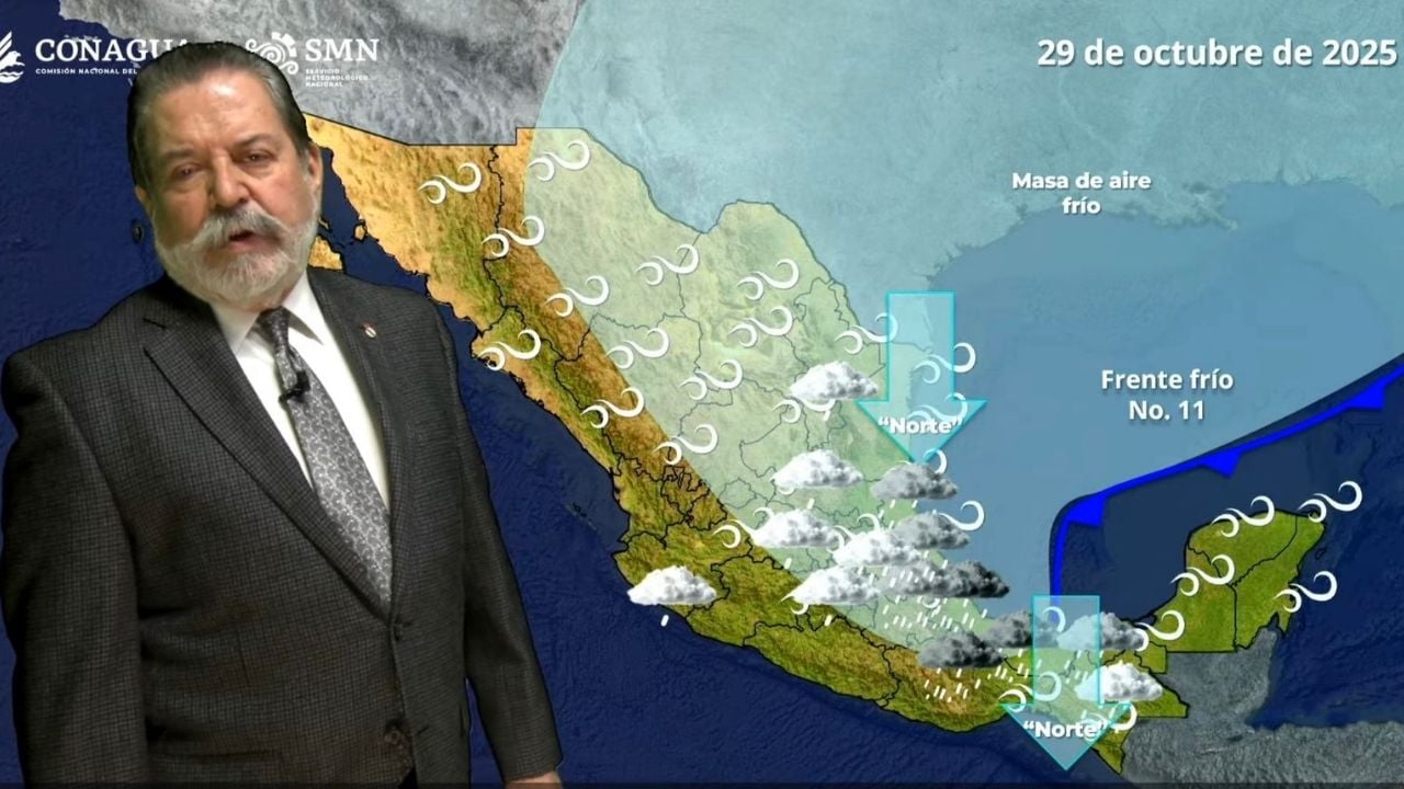

MEXICO CITY (apro) - Frost is forecast in at least three states due to the advance of cold front 11 this Wednesday, according to the forecast of the National Meteorological Service (SMN).
More heavy and intense rains are expected on October 29; likewise, the National Water Commission (Conagua) detailed which entities will be affected by the "Norte" event.
During Tuesday night and Wednesday morning, cold front number 11 and its polar air mass will move over the north and northeast of the country, interacting with the subtropical jet stream, causing strong to very strong winds with possible dust storms in the aforementioned regions.
Showers with possible electrical discharges are also forecast in San Luis Potosí (Media and Huasteca regions) and Tamaulipas (south); as well as isolated rains in Coahuila and Nuevo León.
Similarly, the "Norte" event will begin with gusts of 75 to 90 kilometers per hour and waves of 2.0 to 3.0 meters in height on the coasts of Tamaulipas, in addition to a marked decrease in temperatures with possible frosts in the north of the Mexican Republic.
On the other hand, low-pressure troughs over the interior of the country, in combination with the entry of moisture from the Pacific Ocean, Gulf of Mexico and Caribbean Sea, will generate isolated heavy rains with electrical discharges in Chiapas (south and coast), showers in Jalisco (south and coast), Colima, Michoacán (west, center and coast), Guerrero (coast); Puebla (Sierra Norte, Sierra Nororiental and Valle Serdán regions), Oaxaca, Veracruz (Huasteca Alta, Huasteca Baja, Totonaca and Las Montañas regions), Tabasco, Campeche, Yucatán and Quintana Roo; as well as isolated rains in Querétaro (Sierra Gorda region), Hidalgo (Huasteca region), Veracruz (Los Tuxtlas and Olmeca regions) and State of Mexico.
Scattered heavy rains in VeracruzBy Wednesday, cold front number 11 and the polar air mass driving it will move rapidly over the Gulf of Mexico, causing rain and showers in eastern and southeastern Mexico, including the Yucatan Peninsula; with isolated intense rains in areas of Veracruz, Oaxaca and Tabasco.
Likewise, strong to very strong winds are forecast in states of the northeast, east and southeast of the country; a “Norte” event of 65 to 75 km/h, gusts of 85 to 100 km/h and waves of 3.0 to 4.0 meters in height are forecast on the coasts of Tamaulipas and Veracruz; wind gusts of 65 to 80 km/h in Oaxaca and Chiapas (isthmus and gulf of Tehuantepec) and gusts of 40 to 60 km/h on the coasts of Tabasco, Campeche and Yucatán.
Meanwhile, a marked drop in temperature is expected in most of the Mexican Republic, with a probability of frost in the states of the Northern Plateau and the Central Plateau.
Finally, the influx of moisture from the Pacific Ocean will cause scattered showers and thunderstorms in the west and south of the country, with isolated heavy rains in Guerrero (coast).
Valley of MexicoDuring the morning, clear skies, cold conditions in the region, and very cold with possible frost in high areas of the Valley of Mexico.
In the afternoon, mild to warm conditions, partly cloudy skies and no rain in Mexico City; probability of isolated showers and possible electrical discharges in the southwest of the State of Mexico.
The minimum temperature in Mexico City will be 7 to 9 °C and the maximum 21 to 23 °C. For Toluca, a minimum temperature of 3 to 5 °C and a maximum of 18 to 20 °C are expected. North and northeast winds of 15 to 30 km/h with gusts of 35 to 50 km/h and possible dust devils are forecast, according to the National Meteorological Service (SMN ).
Risks- Wind gusts could cause trees and billboards to fall.
- Very heavy rains with isolated intense downpours (75 to 150 mm): Veracruz (Los Tuxtlas, Papaloapan and Olmeca regions), Oaxaca (north) and Tabasco (west and center).
- Heavy rains with very heavy isolated showers (50 to 75 mm): Puebla (Sierra Norte, Sierra Nororiental, Valle Serdán and Tehuacán-Sierra Negra regions) and Veracruz (Huasteca Alta, Huasteca Baja Totonaca and Nautla regions).
- Showers with isolated heavy rains (25 to 50 mm): Hidalgo (Huasteca, Sierra Alta and Sierra de Tenango regions), Guerrero (coast), Veracruz (Sotavento, Capital and Las Montañas regions) and Chiapas (north and south).
- Intervals of showers (5 to 25 mm): Tamaulipas (south), San Luis Potosí (Media and Huasteca regions), Querétaro (Sierra Gorda region), Tlaxcala, Jalisco, Colima, Michoacán, Campeche, Yucatán and Quintana Roo.
- Isolated rains (0.1 to 5 mm): San Luis Potosí (Altiplano and Centro regions), Hidalgo (Sierra Gorda, Sierra Baja, Valle de Tulancingo and Altiplanicie Pulquera regions), Puebla (Angelópolis region), Nuevo León, Guanajuato, State of Mexico and Nayarit.
- Maximum temperatures of 35 to 40 °C: Baja California Sur, Sonora, Chihuahua (southwest), Durango (west), Sinaloa, Nayarit, Jalisco, Colima, Michoacán and Guerrero.
- Maximum temperatures of 30 to 35 °C: Baja California, Oaxaca, Chiapas (coast), Campeche, Yucatán and Quintana Roo.
- Minimum temperatures of 0 to -5 °C with possible frost: mountainous areas of Baja California, Chihuahua and Durango
- Minimum temperatures of 0 to 5 °C: mountainous areas of Sonora, Coahuila, Nuevo León, San Luis Potosí, Zacatecas, Aguascalientes, Jalisco, Michoacán, Guanajuato, Querétaro, Hidalgo, State of Mexico, Tlaxcala, Puebla, Veracruz and Oaxaca.
- "Norte" event with winds of 65 to 75 km/h and gusts of 85 to 100 km/h: coasts of Tamaulipas and Veracruz; with winds of 35 to 50 km/h and gusts of 65 to 80 km/h: Oaxaca and Chiapas (Isthmus and Gulf of Tehuantepec), intensifying in the afternoon and evening.
- "Norte" event with winds of 25 to 35 km/h and gusts of 40 to 60 km/h, during the night: coasts of Tabasco, Campeche and Yucatán.
- Winds of 20 to 35 km/h with gusts of 50 to 70 km/h: San Luis Potosí.
- Winds of 10 to 20 km/h with gusts of 35 to 50 km/h: Baja California, Sonora, Chihuahua, Coahuila, Nuevo León, Zacatecas, Guanajuato, Querétaro, Hidalgo, State of Mexico, Mexico City, Tlaxcala, Puebla and the coast of Quintana Roo.
- Waves of 3.0 to 4.0 meters in height: coasts of Tamaulipas and Veracruz; during the night: Gulf of Tehuantepec.
- Waves of 1.5 to 2.5 meters in height: coasts of Tabasco, Campeche and Yucatán, increasing during the early hours of Thursday.
proceso